Saturday September 4, 2010
Andrews, Texas
Andrews and their bike ride are a well kept secret. When I told people that I was going to Andrews for a bicycle ride, I was asked where is that? Easy, 15 miles east of Frankel City out in West Texas. You know, close to Shafter Lake.
Andrews held its 2nd annual ride in conjunction with its blue grass festival. Both are held in Florey Park just north of Andrews. Florey was a town established in 1909 prior to Andrews's becoming a county in 1910. Florey Park was a camp site for the Humble Oil and Refining Company and its residents planted trees and grass (obviously the oil field workers brought their wives and families with them) developing an oasis in a sparsely vegetated area. Humble donated the land to be used as a park in 1958.
There are some unique things about Florey Park. Not unique is that they recently built showers for campers (and bicycle riders). But the unique thing is the sign just before you enter the bathroom/shower area:
You may be in West Texas when----------
Packet pick up was the morning of the ride and was relatively painless. The only glitch was that I and a few other old timers are getting hard of hearing. For the goodie bag, we were offered "--nuts or doughnuts?" The genltleman in front of me chose doughnuts. A strange look came into the lady volunteer's eyes when a younger person with good ears clarified "--nuts or no nuts." Seems some people are allergic to nuts so they had two different packets. That item of thoughtfulness was evident throughout the day's ride. The volunteers were great.
Far left Andrews County Judge, Brian the event director, the "doughnut" lady and a rider. (Hope the lady volunteer has a sense of humor--otherwise a rattlesnake may be in my goodie bag next year)
A little before 8 a.m., Brian lined us up for a briefing.
As there were a lot of turns in the route, what I heard was "follow the arrows". I understand there were between 50-60 of us in the ride. Team Hobbs, from Hobbs, New Mexico, had an outstanding turnout.
As we took off, I started with the 20 mph group and was quickly dropped. Next I tried to latch on to the 16-18 mph group and was quickly dropped. (For those who don't want to enlarge the photo, the little specks in the distance are the 16-18 group). So I settled into my owm pace. Christine caught up to me and from behind I heard "Couldn't keep up with them huh?" I didn't retort that SHE was drafting off me. Sometimes silence is best.
So many rides advertise themselves as a "warm-up for Hotter'n Hell Hundred". I think Andrews should advertise themselves as "the recovery ride after Hotter'n Hell Hundred". Being part of the Permian Basin, a great part of the ride is on level ground. There were some rollers but the steepest hill was about a 3% grade. So it is a fast, "easy" ride to work out the kinks that HHH put in you and to get the muscles tuned up for preparing for the Fort Davis Cyclefest.
Ranch
and Rig
with a lot of ranch/oil wells mixed.
Our first glimpse of Shafter Lake (way in the back ground) didn't give us a good idea of the lay out. On our return route, we had a chance for a closer look.
I took a lot of pictures of the various pump jacks. The ones around San Angelo are the smaller ones, maybe 6' tall (meaning shallow well) versus the huge pump jacks in the Andrews area. Some looked two stories tall.
You may be in the middle of an oil field if-------
Let's be clear about this.
And don't say I didn't warn you.
We asked the friendly volunteers at a wayside rest stop about the signs. They explained that the signs were to caution people that if technicians were working on a well some gas may escape. They weren't worried and they live there. (Note they weren't wearing protective masks). Still, it was exciting to see the different signs posted throughout the area.
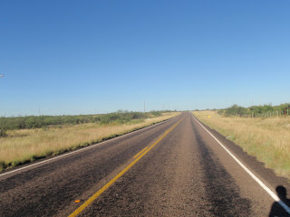
On one stretch of road, Christine asked me to take a picture. I asked "Why?" She said the song "Miles and miles of Texas" kept going through her mind. So I took a picture.
And another one.
And----. Note that the road seems to be about a 1% incline. A good thing about this ride is that after you have a mile of 1% incline, you get a mile of 1% decline. The same with the little 3% rollers, for every climb there is a down.
We were impressed that what would have been perhaps the hardest climb of the ride, the highway department had cut through to keep the highway fairly level. As a matter of fact, the highway between Midland and Andrews is so straight and level that the speed limit is a safe 75 mph.
You may be a redneck if--------.
Next to last wayside area. Brian, left, was the designated SAG vehicle driver and we saw him back and forth all day watching over the riders. To everyones's credit, there were no mechanical or physical failures on the ride. But we really appreciated the fact that help was never far away if needed. The lady at the rest stop was very friendly and helpful. And helpful--the gentleman in sun glasses requested that we lean our bikes up against his BIG Harley bike rather than lay our bikes down on the gravel. Outstanding.
Shafter Lake, like Florey, is a ghost town. Shafter lost by a narrow margin to Andrews for the county seat in 1910 and rapidly declined thereafter. Shafter Lake lies in a 50 foot depression and is a salt lake.
I counted three pumping jacks in the lake bed. I would like to know the techniques of drilling as during the 30's cable tool was the drilling rig. How did they stablize the rig? How did they get it out there for that matter? What did they use for a sludge pit? Etc.
Subject too deep for me. If you are at a ghost town tourist attraction, what do tourists do?
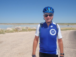
Pose for a picture of course.
We are aware that some riders cannot understand our way of riding. Instead of riding at continuous break-neck speed, we stop, look around, smell the flowers (if available), and generally enjoy our rides.
As we left the Shafter Lake area--
We were faced with more miles and miles of Texas.
This rest stop manned by the County Judge referenced earlier at the packet pick up area, a retired gentleman, and an Andrews school official was the first--and last rest stop. It was at this cross road that going out we went one way and coming back we took a different route to Florey Park. They verified what I was talking about with our style of riding versus some others. The big group of riders whizzed by the rest stop "about two hours earlier" said the Judge. All of the other rest stops had said that the large group did not stop for water or refreshments. Maybe our definition of "recovery ride" is different.
What do laid back riders do at the last rest stop?
Pose for pictures!!
As we turned on Highway 385 beginning the last leg of our trip, I was really impressed by another pump jack.
I would really like to know the story behind this unusally painted jack. A bored oil field worker? A functional color? A pump that was to be shipped to a war torn oil producing country? There has to be a story.
But our story ends as we pull back into Florey Park.
Whether one wants a nice recovery ride after HHH, or a relatively flat 62 mile crit venue, consider the Ranch and Rig Ride at Andrews, Texas
.JPG)


No escarpment hills--Fantastic!
ReplyDeletePit stops with food--Great!
Sag Wagon Patrol--Excellent!
Poisonous Gas Alert...okay.
SNAKES????? I'm outta there!!!!!!!!!!
Getting ready for the Big Move 50 k. Ride this Sunday in Our Town. There's no snakes on our route, so I'm okay with it.
Rosemary
@Steadfast Ahoy. Good luck on your ride. I hope you post an account of your ride--hopefully with some pictures. Should be pretty country.
ReplyDeleteThanks for the great post. It's funny that you pointed out the poisonous gas signs - the alternate name for the ride was "Danger! Poisonous Gas May Be Present" 25/50/100K - but I figured that might scare off a few riders. Once again, thanks for the post. You guys were a delight and we look forward to seeing you again next year!
ReplyDelete