
Fort Davis, Texas
September 18, 2010

A drawing of the route and a picture of the elevation on the back of the t-shirt is a good synoposis of the ride. If I just showed the above two pictures and a picture of a cyclist gasping with his tongue hanging out, I could end the story now.
But, the day began with a great sunrise.

The temperature was supposed to be around 57-59, but even with the previous evening's drizzling rain, it did not seem too cold, so most of our cool weather gear was thrown back in the clothing bag.

We parked by Brian Backlund and admired his new Cyclefest jersey. It had Sawtooth Mountain on the front and a picture of the route/elevation on the back. Actually the features turned out to be handy as some of us would study the back of one's jersey to determine where we were and WHAT was THAT we just climbed.

There were a little over 430 registered, so I didn't get to see all of the San Angelo riders there. Pictured are Brian Backlund, Christine Jones, and Rick Ogan in the jersey with a white star. Seated behind Christine was Dorothy Langdon--resting for the big day ahead of us. Somewhere in the crowd were Chad Freeze, Hector Acton, James Forbes, Ty Johnson, and Christine Buckstead.

Historic Prude Ranch was the starting and ending point.

One can tell by the varied dress riders were unsure of what to expect--cool/warm. Turned out to be both.

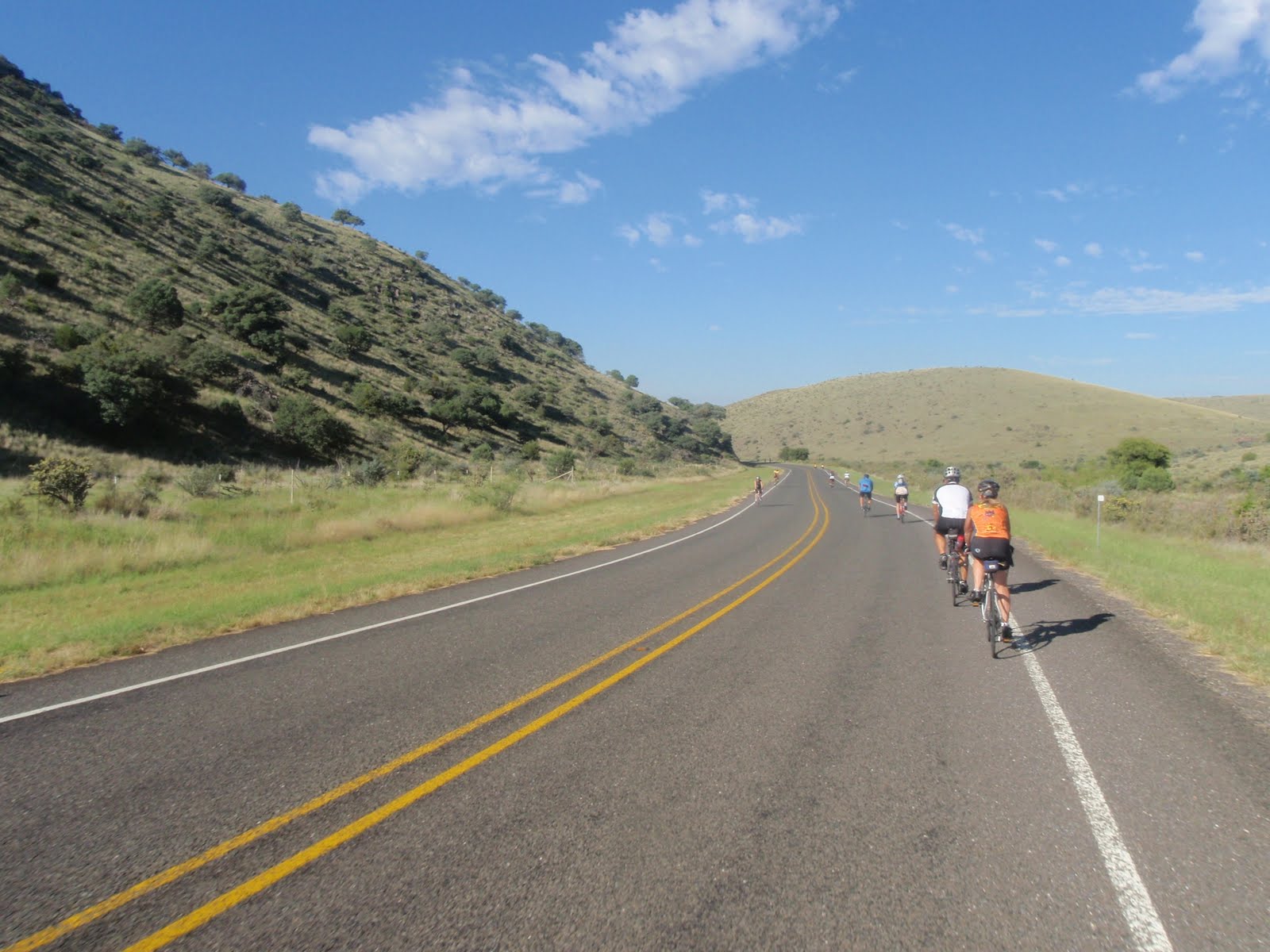
Heading off into the canyon was a little chilly.


After we passed through Fort Davis, the terrain leveled out as we traveled toward the distant mountains. Dorothy was leading us out.

I incorrectly stated that the terrain leveled out. Actually, we went up for a little over 1,400 feet in the first 20 miles but most of it is such a slight incline that some call it a false flat.

At the first rest area, the sun was out, riders were warmed up so the volunteers offered to take extra clothing back to the start area. They even provided plastic bags should someone not have known about the service.

Rick, middle, and Brian, right, enjoyed the break.

And up rolled Ed Todd, a good friend of mine from Midland.

Rick lead as we continued our slow gradual climb. We all settled back to enjoy the scenery.

In between rest stops 1 and 2, the terrain still seemed level (even though we are climbing) but the mountains off to our side were starting to get closer.


And "suddenly" we were at rest stop 2. Rick, middle, talks to two riders, and Christine, right middle, was talking to a new acquaintance. Rest stop 2 was about 30 miles into the ride.

The ride just after rest stop 2 was deceiving, but if the shot were more realistic, one would have seen by the upcoming "incline" that we were getting closer to the "good part".

After the small 5% grade roller, Christine was still smiling.

Brian, Christine, and Dorothy (up front) approached another roller. As I recall this was another 5% grade.

After repeated rollers and about 40 miles, we were lucky enough for one of Dorothy's water bottles to be leaking. She stopped to empty the remaining contents into her Camelbak. Chrtine looks relaxed...

however, after I tried to get a perspective shot of the three riders coming up the hill, I noticed that maybe Christine wasn't as relaxed as previously presumed. She told me later that, in bicycle speak, her legs were pretty much gone by that time.

After rest stop 2 there were three to four good rollers, and then once again the terrarin appeared to level even though we were still climbing.


The camera cannot capture the sights we were seeing. And what is not depicted is that we were starting on a long steady 4-6% climb.

At this point in the journey, we came upon a rare level spot with a picnic area. Volunteers had water and refreshments at this area even though it was not an official stop. Past experience taught the volunteers that this "rest stop 2 1/2" was much needed. As Christine rolled into the area, a volunteer rushed out to assist her as she dismounted. It had been a tough incline. I was glad that I held the camera so that no one could see my huffing and puffing.

This was the only shot I have of the Bear Mountain climb. This was the start of a one mile climb of 8-9% with a few spots that registered 11%. Bear Mountain isn't the steepest grade of the ride; it was tough because it was a sustained climb. After taking this shot, both hands were busy holding onto the handle bars just to keep enough speed to stay upright.

Christine celebrating. This was the fourth year that we have ridden the Fort Davis mountains, but it was Christine's first time to pedal all the way up Bear Mountain. She had good reason to celebrate. For three years she has referred to Bear Mountain as B_tch Mountain. Even though she has now conquered the mountain, I don't think she has renamed it yet.

View at rest stop 3.

Dorothy arriving at rest stop 3.

A view from which we just came. It does not tell the story.

Ed Todd joined us at the top of the Bear Mountain climb.

As I was standing around, Dorothy asked for the camera saying that there was a nice mountain in the background and I just happened to be standing in front of it.

There was nice scenery all around us.


From Bear Mountain there is a short reprive of a downhill.

The next mountain to climb was Fisher Mountain. The best thing to say about it is that it was not a sustained climb such as Bear, but it didn't lack in challenge.
Probably the best story of Fisher Mountain--at least for recreational riders--is a series of pictures I took of Christine coming up. Keep in mind that Fisher was also 8-9% for the better part with an occasional 13-14% grade before it would drop back to 8%.


Way to go Christine. It was the first time to climb Fisher Mountain without pushing the bike up. She mentioned that her knees were screaming at her, but she made it.

Dorothy at the top of Fisher Mountain. She looked fresh and rested without a care in the world. I think she knew it was "all downhill" from here. Actually there would be three more climbs but at an average of 7% and the "Wall" about two miles from the finish.

Some scenery right after the rest stop.


One would have to enlarge the picture to identify the structures on top of the mountains--McDonald Observatory. The rider knows that the finish is just 15 or so miles.

Just past McDonald Observatory is the part that keeps Christine coming back year after year. The picture marked the start of a nine mile drop of 1,000 feet. There were a few times that one had to pedal. Everyone is cautioned to keep the legs moving at least a little as at the bottom of the drop is a hill they call "The Wall" or "Heart Break Hill". You had been gliding along and then suddenly had to climb with cold legs. As I recall, the wall was "only" about 7% grade, but after not pedaling--and after 72 miles--one's legs--my legs--did not have a sense of humor and protested.

Almost at the bottom. It was the first time since the start of the drop that I was going slowly enough to let go with one hand to take a photo.

Soon after The Wall, the Prude Ranch buildings were seen in the distance, and you knew you were close to home sweet home.

As always, the memories of the sweat, puffing, pain, shakey knees, and cramps quickly faded, and just the good memories of sweet mountain air, granite monoliths, conquered hills remain. So we have hotel reservations for next year's ride, and are looking forward to it. Never can tell...I might race up Mt. Locke with Ed next year, but that will be another story.


Wow! You guys sure do keep going!!! Energizer Bunnies. This post reminds me of cycling with BackRoads in Italy. Every day it was either up hill or down--no flat roads to be had. I was younger then and my "roving" tendonitis hadn't become problematic. How I managed to breeze thru the 50K Big Move Ride earlier this month is beyond me. I am paying for it now with the recurrent knee problem. Still, our team of 18, raised over $25,000. In all, $410,000 was raised towards the new Walker Cancer Center in Our Town.
ReplyDeleteWay to go, Roy and Christine.
Rosemary